AUSTIN US
AUSTIN
HomeSlopes & WallsSoil Erosion Analysis

Soil Erosion Analysis in Austin: Protect Your Project from Hillside Failure

Rigorous testing. Clear reporting.

LEARN MORE

Too many builders in the Balcones Fault zone assume that if the topsoil looks stable, the cut won't move. Then the first heavy rain undercuts the toe, and the retaining wall starts to tilt. We've seen it happen on slopes off Bee Caves Road and along the Colorado River terraces. A proper soil erosion analysis in Austin identifies exactly where the shear plane sits and how the infiltration rate changes after the clay dries. Without that data, you're guessing. Our team runs the full suite — from rill assessment to gully erosion modeling — so you know before the dozer shows up. We combine this with a drainage geotechnical study to map subsurface flow paths that accelerate erosion.

Illustrative image of Soil erosion analysis in Austin
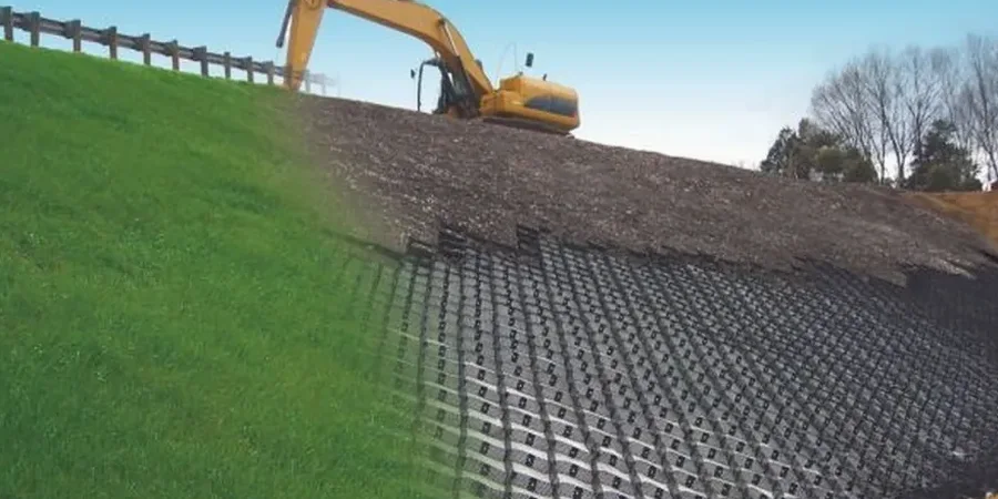
The first heavy rain undercuts the toe, and the retaining wall starts to tilt — we've seen it happen on slopes off Bee Caves Road.

Our service areas

Process overview

West Austin's limestone ridges behave nothing like the deep alluvial clays in Onion Creek. On one project near Loop 360, the silt-loam cap was only 12 inches thick over weathered marl — any runoff quickly stripped the cover and exposed bedrock. That contrast matters when you write the erosion control plan. Our soil erosion analysis in Austin covers both scenarios: we measure dispersion ratios, slake durability, and the critical shear stress for each horizon. We also apply the RUSLE2 framework to estimate annual soil loss in tons per acre. For sites with steep gradients, we cross-reference this data with a subgrade stabilization evaluation to confirm that the base layer won't wash out under traffic loads.
Technical reference — Austin

Local context

The City of Austin's Land Development Code requires erosion and sedimentation control plans for any project disturbing more than one acre. But even smaller sites fall under the Edwards Aquifer Recharge Zone rules. We've seen fines pile up because a developer skipped the soil erosion analysis in Austin and the silt fence didn't match the actual soil type. The real risk isn't just regulatory — it's structural. When the topsoil erodes, the foundation bearing capacity drops. We follow the IBC 2021 Chapter 18 and the Texas Erosion and Sediment Control Handbook to set proper buffer widths, check dam spacing, and outlet stability. That saves you from redesigning the retaining wall halfway through excavation.

Need a geotechnical assessment?

Reply within 24h.

Email: contact@geotechnicalengineering1.com

Relevant standards


IBC 2021 Chapter 18 (excavation & grading), ASTM D4222 (dispersion ratio), NRCS RUSLE2 methodology, Texas Erosion and Sediment Control Handbook (TCEQ)

Technical data

ParameterTypical value
Shear stress threshold (critical)0.5 – 2.5 Pa (depending on texture)
Soil loss tolerance (T factor)2 – 5 tons/acre/year (NRCS)
Dispersion ratio (ASTM D4222)< 15% stable; > 30% dispersive
Slope length (LS factor in RUSLE2)up to 300 ft for typical Austin lots
Infiltration rate (field test)0.2 – 1.5 in/hr (clay-silt range)
Clay content (Atterberg limits)25 – 55% plasticity index

Visual overview

FAQ


How is soil erosion analysis different from a standard geotechnical report?

A standard geotech report focuses on bearing capacity, settlement, and soil classification. An erosion analysis specifically quantifies soil loss rates (tons/acre/year), identifies dispersive clays, and recommends erosion control measures. In Austin, where the Balcones Fault creates highly erodible clay/shale interfaces, this distinction is critical for both permitting and long-term slope stability.

What is the typical cost for a soil erosion analysis in Austin?

For a typical residential lot (1–3 acres), the cost ranges between US$820 and US$2,280 depending on site complexity, number of test pits, and whether GIS modeling is required. Larger commercial sites with multiple drainage basins fall at the higher end. This includes field work, laboratory testing, and a stamped report suitable for city permit submission.

Do I need an erosion analysis if my lot is flat?

Yes, especially in Austin's clay soils. Even a 2% slope can generate enough runoff to cause sheet erosion and deposit sediment into storm drains or creeks. The city's code requires erosion controls on any site with bare soil, regardless of slope. We can run a simplified RUSLE2 check that usually takes half a day and confirms whether your standard silt fence is adequate.

How long does the analysis take from start to finish?

Field sampling takes one day for most sites. Lab work — dispersion, slake, and Atterberg limits — adds 5 to 7 business days. The GIS modeling and report writing require another 3 to 5 days. Total turnaround is typically 10 to 14 days. We can expedite to 7 days for an additional fee if you have a tight permitting deadline.

Location and service area

We serve projects across Austin.

Location and service area