AUSTIN US
AUSTIN
HomeGeophysicsMicrotremores HVSR (Nakamura)

HVSR Microtremor Survey in Austin: Passive Seismic Site Characterization

Rigorous testing. Clear reporting.

LEARN MORE

The portable seismometer sits on weathered limestone and clay, recording ambient vibrations for about 40 minutes per station. That brief window captures enough microtremor data to define the fundamental resonance frequency of the soil column beneath an Austin site. Unlike active seismic methods that require a hammer or weight drop, the HVSR (horizontal-to-vertical spectral ratio) technique relies on natural background noise — wind, traffic, distant machinery. The field team deploys the instrument in a grid pattern, covering the project footprint systematically. Each measurement point yields a spectral ratio curve that reveals the impedance contrast between softer overburden and the underlying bedrock. For projects along the Balcones Fault Zone, this passive approach provides a non-invasive first pass at site classification without drilling. Before committing to borehole locations, the engineer can review these profiles to target critical zones, then follow up with a MASW Vs30 survey for shear-wave velocity confirmation.

Illustrative image of HVSR microtremor survey (Nakamura method) in Austin
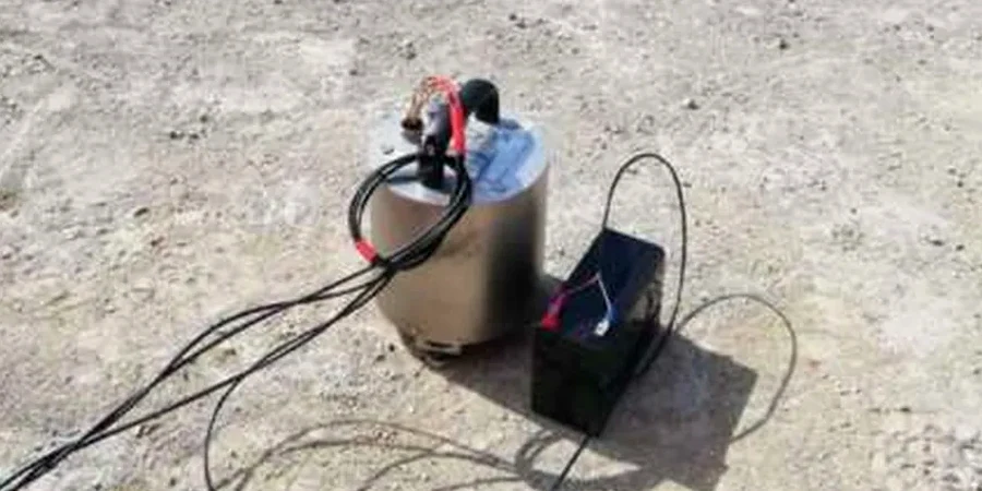
The HVSR microtremor survey identifies the fundamental resonance frequency where the site will amplify seismic motion — critical data for Austin's variable soil-over-limestone geology.

Our service areas

Process overview

A common mistake among developers in Austin is skipping the HVSR step and going straight to SPT borings, which miss the basin-edge amplification effects that control seismic demand. The HVSR microtremor survey identifies the fundamental frequency (f0) where the site will resonate during an earthquake. If that frequency coincides with the building's natural period, resonance amplifies shaking significantly. The method works reliably on the variable geology of the Edwards Plateau, where thin soils overlie Cretaceous limestone. Key parameters derived from the HVSR curve include:
Technical reference — Austin

Local context

Austin sits at elevations ranging from 130 m near Lady Bird Lake to over 300 m on the western hills. This topographic variation, combined with the Balcones Fault Zone, creates sharp lateral changes in soil thickness. A site on the east side may have 20 m of clay over marl, while a site 2 km west has less than 3 m of soil on limestone. The HVSR microtremor survey detects these transitions quickly. Without it, a project could misclassify the site per ASCE 7, assigning a Site Class C instead of the correct Site Class D or E. That error directly affects the seismic base shear calculation, potentially under-designing the lateral system for the building's actual demand.

Need a geotechnical assessment?

Reply within 24h.

Email: contact@geotechnicalengineering1.com

Relevant standards


ASCE 7-22 Section 11.4 (Site Class criteria for Vs30 and f0), SESAME Guidelines (Site Effects Assessment Using Ambient Excitations, 2004), ASTM D7400-19 (Standard Test Methods for Downhole Seismic Testing – reference for passive methods)

Technical data

ParameterTypical value
Measurement duration per station40 - 60 minutes
Frequency range analyzed0.2 Hz – 20 Hz
Number of stations per project6 – 20 (grid or linear array)
Spectral ratio peak amplitude (A0)2.0 – 6.0 (site amplification factor)
Depth of impedance contrast estimated10 – 80 m depending on Vs profile

FAQ


How does the HVSR microtremor survey differ from a MASW survey?

HVSR uses ambient vibrations (passive) and identifies the fundamental resonance frequency (f0) of the soil column. MASW uses an active source (hammer or weight drop) and measures shear-wave velocity with depth. HVSR is faster and cheaper for initial screening; MASW provides a velocity profile. The two are complementary for ASCE 7 site classification.

What is the typical cost range for an HVSR microtremor survey in Austin?

For a standard project with 8–12 stations, the cost ranges between US$1,420 and US$2,370. Larger grids or projects requiring 3D tomography may fall on the higher end. Contact us for a firm quote based on your specific site size and access conditions.

How long does it take to complete an HVSR survey and get results?

Fieldwork for a 10-station grid takes one day. Data processing and interpretation require 2–3 additional business days. A preliminary report with f0 maps and amplification factors can be delivered within one week of mobilization.

Do I need an HVSR survey if my Austin site already has SPT borings?

Not always, but often yes. SPT borings give soil classification and N-values at discrete depths, but they do not directly measure resonance frequency or amplification. For sites where the building period is unknown or the soil profile varies laterally, an HVSR survey adds critical dynamic information that SPT alone cannot provide.

Location and service area

We serve projects across Austin.

Location and service area